Transecting a cranberry bed with the GPR, the lack of ice required the unit to be towed in a wheelbarrow and the antenna dragged behind on the bed.
Plymouth County Soil Survey
Using GPR, GPS and GIS to Inventory Peat
Resources of Cranberry Beds in Massachusetts
(Note: The term "Peat" in this article reefers
to a geologic deposit of organic sediments)
Article on Cranberry Bed
Soil Map Units from Cranberries Magazine |
GPR
Investigations on Cranberry Beds in Plymouth County, MA (Article from 2nd
Govt Workshop on GPR)
Instructions on how to download GPS data and create contour maps
Since the early 1990's the Plymouth County Soil Survey has been using the ground-penetrating radar (GPR) to map the soil and geologic deposits within areas used to produce cranberries. The early studies showed a wide variety of uses for GPR technology on the organic soils used for cranberry production (1). The GPR data help to establish cranberry bed soil map units and interpretive data for the use and management of cranberry bed soils (A guide to cranberry bed map units).
The early investigations involved establishing a grid on the beds using a transit or simple measuring tape. The grid was necessary to correlate GPR event marks with known positions so the data from the GPR could be entered into a program to produce a contour map of the peat thickness. Establishing the grid usually took a full day with 3-4 people setting up the grid. Another day was required to transect the bed with the GPR. This also required 3-5 people if there was no ice on the bed (which was the situation most of the time). An additional half-day was needed to interpret the radar profiles, enter the data into a computer program to generate a contour map showing peat thickness.
Transecting a cranberry bed with the GPR, the lack of ice
required the unit to be towed in a wheelbarrow and the antenna
dragged behind on the bed.
The amount of time and personnel required to conduct a complete radar survey of a cranberry bed made it impractical to use the GPR to inventory and map cranberry beds and other areas of organic soils. The radar was primarily used for on-site soil investigations which aided in construction and engineering designs or to determine the best placement of dikes and ditches.
In 1994, the Plymouth County Soil Survey acquired a PLGR Global Positioning System (GPS) to use for soil survey operations. The PLGR's are highly accurate positioning systems which do not need post-processing to give accurate position. The PLGR's were field tested for soil survey use and found to have a high potential for field mapping (Using Global Positioning Systems To Increase Accuracy in Soil Survey Field Mapping). The PLGR's are also used for GPR investigations to geo-reference the survey data. This reduced the need to grid areas prior to the survey. For work on cranberry beds the perimeter of the bed was walked, marking way-point locations at various points, then the bed was transected with the GPR and event-marks were geo-referenced with the PLGR. The data could then be downloaded and entered into the SURFER program to produce contour plots of peat thickness and to calculate the peat volumes within cranberry beds.
|
|
|
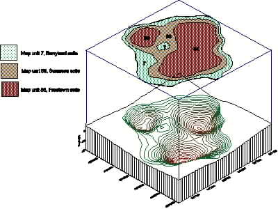
Example of a contour plot of a cranberry bed (State Bog 19, UMASS Cranberry Experiment Station) surveyed with a GPR and PLGR GPS, coordinates are UTM, NAD 83. TOP: Bottom map is a 3-D plot of the bed morphology, top map shows the corresponding soil map units. BOTTOM Soil map (CIR) of State bog 19.
The use of the GPS saved tremendous time and provided maps that were geo-referenced in real world coordinates. Time was still required to walk the bed perimeter and enter the data. Another problem was the contour maps produced (above image) lacked a base map to locate your position on the bed. These problems were overcome by using a Geographic Information System (GIS) to assist with survey operations. The GIS is used to geo-referencing the bed perimeter and overlay the contour plot produced from the SURFER program onto a base map such as a USGS Topographic map or a Digital Orthophoto.
In mid January 2000 conditions finally became favorable to use the radar to map cranberry beds. Cold weather provided sufficient ice thickness (the first time in 4 years) on the beds to allow the GPR unit to be towed on a sled (image below). The ice allowed the beds to be surveyed with only two people.
Radar survey on a cranberry bed the easy way. The unit is
pulled on the ice in a sled with skis attached.
Three beds were surveyed with the GPR and GPS in less than 3 hours, excluding drive time. A 25-acre bog took only a half-hour to complete a full radar survey. A quick estimate of the time and cost to survey a 25-acre bed is as follows:
Survey w/o GPS & GIS (Jelly Bog) Personnel required 6 |
Survey using GPS & GIS (Piney Wood Bog) Personnel required 2 |
Another benefit to using the GIS was the ability to overlay the contour map of the bed on an Orthophoto allowing more uses for the map. The maps produced with the radar data are used by the cranberry farmers to aid with the management of the beds for dike placement, irrigation design, bed leveling, precision agriculture, and various other uses. The maps also make it possible to calculate the volume of organic sediments for carbon research and fuel resource inventory.
The following are examples of the type of maps produced using GPR, GPS, and GIS techniques:
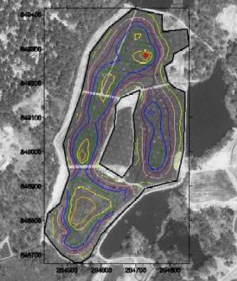
Piney Wood bog surveyed with a SIR-System-3 GPR and PLGR GPS. Contour map shows the thickness of peat in one foot contour intervals (yellow = 1 foot, blue = four foot, and red -= 8 foot contour). Maximum peat thickness is 8 feet, total volume of peat = 127,007 cubic meters. Coordinates are Mass. State Plane, NAD 83.
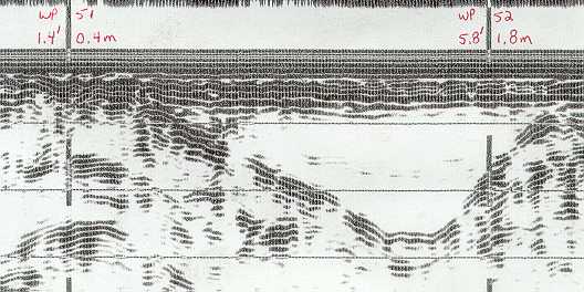
Radar profile from Piney Wood bog (waypoint 51 and 52) dark interface is the peat-mineral contact. The profile shows the variability of peat distribution, each waypoint is approximately 50 feet apart, the depth of peat ranges from 0 to 8 feet.
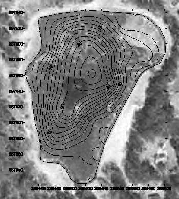
Pembroke Bog, contour map shows thickness of peat in two-foot intervals. Maximum peat thickness estimated 26 feet. This 6-acre bed contains 91,789 cubic yards of peat. Coordinates are Massachusetts State Plane, NAD 83.
(1) Doolittle, J., Davenport, J., Fletcher, P., Turenne, J. 1990. Morphometry of cranberry bogs formed in kettles and outwash channels in southeast Massachusetts. P. 83-92. IN: (Eds) j. m. Kimble. Proceedings Eight International Soil Correlation Meeting (VII ISCOM) : Characterization, Classification and Utilization of Wet Soils. Louisiana and Texas. 6 to 21 October 1990. p. 327.
Click Here for Instructions on How the Maps were produced.