 Click
for photo of this pedon
Click
for photo of this pedon
Click
for photo of this pedon
| Slope | Elevation | Aspect | MAAT | MSAT | MWAT | MAP | Frost-Free Days | Drainage Class | Slope Length | Upslope Length |
|---|---|---|---|---|---|---|---|---|---|---|
| 1 percent | 39.6 meters | 140° | 9.4° C | 20.3° C | -1.7° C | 1234 millimeters | 197 days | very poorly |
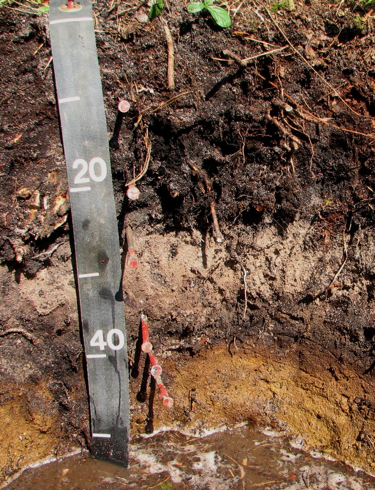
Oe --- 0 to 9 centimeters; very dark brown (7.5YR 2.5/2) moist, broken face and; dark yellowish brown (10YR 4/4) moist, rubbed, moderately decomposed plant material; weak medium granular and weak fine granular structure; very friable; moderately few coarse roots throughout, many fine roots throughout and many very fine roots throughout; negative reaction to alpha-alpha' dipyridyl; pH was measured but was off chart.; abrupt smooth boundary. Oa --- 9 to 18 centimeters; black (10YR 2/1) moist, rubbed and; black (10YR 2/1) moist, broken face, highly decomposed plant material; weak coarse granular and weak medium granular structure; very friable; moderately few coarse roots throughout, many medium roots throughout, many fine roots throughout and many very fine roots throughout; negative reaction to alpha-alpha' dipyridyl; pH was measured to be off the chart.; clear smooth boundary. A --- 18 to 23 centimeters; very dark gray (10YR 3/1) moist, sand; dark gray (10YR 4/1) dry; weak very fine granular structure; very friable; common medium roots throughout, common fine roots throughout and common very fine roots throughout; negative reaction to alpha-alpha' dipyridyl; very strongly acid, pH 5, Chlorophenol red; There are 25% stripped sand grains in the horizon.; clear wavy boundary. Eg --- 23 to 32 centimeters; 80 percent grayish brown (10YR 5/2) moist and 20 percent brown (7.5YR 5/2) moist, sand; massive; very friable; moderately few medium roots throughout, moderately few fine roots throughout and moderately few very fine roots throughout; 5 percent subrounded 2 to 10 millimeters medium gravel sized mixed rock fragments; positive reaction to alpha-alpha' dipyridyl; very strongly acid, pH 5, Chlorophenol red; A positive reaction to alpha, alpha-dipyridyl was observed.; clear smooth boundary. Bh --- 32 to 37 centimeters; black (5YR 2.5/1) moist, sand; weak medium subangular blocky structure; friable; moderately few medium roots throughout, moderately few fine roots throughout and moderately few very fine roots throughout; 5 percent subrounded 2 to 10 millimeters medium gravel sized mixed rock fragments; positive reaction to alpha-alpha' dipyridyl; strongly acid, pH 5.4, Chlorophenol red; A positive reaction to alpha, alpha-dipyridyl was observed.; abrupt wavy boundary. Bhs --- 37 to 42 centimeters; dark reddish brown (5YR 3/3) moist, sand; weak medium subangular blocky and weak fine subangular blocky structure; friable; moderately few fine roots throughout and moderately few very fine roots throughout; 5 percent subrounded 2 to 10 millimeters medium gravel sized mixed rock fragments; positive reaction to alpha-alpha' dipyridyl; strongly acid, pH 5.4, Chlorophenol red; A positive reaction to alpha, alpha-dipyridyl was observed.; gradual broken boundary. Bg --- 42 to 54 centimeters; 85 percent yellowish brown (10YR 5/4) moist and 15 percent dark reddish brown (5YR 3/3) moist, sand; massive; friable; moderately few medium roots throughout; 2 percent (common) fine prominent irregular noncemented yellowish red (5YR 4/6), moist, masses of oxidized iron clear on surfaces along root channels; 5 percent (common) medium prominent irregular weakly cemented reddish black (2.5YR 2.5/1), moist, ortstein nodules with clear boundaries at top of horizon; 10 percent subrounded 2 to 10 millimeters medium gravel sized mixed rock fragments; positive reaction to alpha-alpha' dipyridyl; moderately acid, pH 5.6, Chlorophenol red; A positive reaction to the alpha, alpha-dipyridyl was observed. Some firm consistences were also observed in the horizon.; clear wavy boundary. B'hs --- 54 to 74 centimeters; dark brown (7.5YR 3/3) moist, gravelly sand; massive; very friable; 3 percent (common) fine faint irregular noncemented dark reddish brown (5YR 3/4), moist, masses of oxidized iron clear around rock fragments; 20 percent subrounded 2 to 10 millimeters medium gravel sized mixed rock fragments; strongly acid, pH 5.4, Chlorophenol red; clear wavy boundary. Cg1 --- 74 to 85 centimeters; light brownish gray (2.5Y 6/2) moist, gravelly sand; single grain; loose; 7 percent (common) coarse prominent irregular noncemented yellowish brown (10YR 5/6), moist, masses of oxidized iron clear throughout and 8 percent (common) medium prominent irregular noncemented yellowish brown (10YR 5/6), moist, masses of oxidized iron clear throughout; 15 percent subrounded 2 to 10 millimeters medium gravel sized mixed rock fragments; strongly acid, pH 5.2, Chlorophenol red; clear wavy boundary. Cg2 --- 85 to 170 centimeters; light brownish gray (2.5Y 6/2) moist, sand; single grain; loose; 15 percent (common) coarse prominent irregular noncemented yellowish brown (10YR 5/6), moist, masses of oxidized iron clear throughout and 15 percent (common) medium prominent irregular noncemented yellowish brown (10YR 5/6), moist, masses of oxidized iron clear throughout; 5 percent subrounded 2 to 10 millimeters medium gravel sized mixed rock fragments; moderately acid, pH 5.6, Chlorophenol red. Laboratory Analysis for Pedon Above:
*** Primary Characterization Data
***
Pedon ID:
S07MA023003
( Plymouth,
Massachusetts )
Print Date: Jan 27 2008
12:29PM
Sampled as on Aug 02,
2007 :
Berryland ; Sandy, mixed,
mesic Arenic Alaquod
Revised to :
United States Department
of Agriculture
SSL
-
Project
C2007USMA119 Plymouth Co.
Natural Resources
Conservation Service
-
Site ID
S07MA023003-Berryland Lat: 41� 54' 17.20"
north Long: 70� 43' 16.10"
west NAD83 MLRA: 144A
National Soil Survey
Center
-
Pedon No.
07N0687
Soil Survey
Laboratory
-
General Methods 1B1A,
2A1, 2B
Lincoln, Nebraska
68508-3866
Layer
Horizon
Orig Hzn
Depth (cm)
Field Label 1
Field Label 2
Field Label 3
Field Texture
Lab Texture
07N04199
Oe
0-9
S07MA023-003-1
07N04200
Oa
9-18
S07MA023-003-2
07N04201
A
18-23
S07MA023-003-3
COS
07N04202
Eg
23-32
S07MA023-003-4
COS
07N04203
Bh and Bhs
32-42
S07MA023-003-5
COS
07N04204
Bg
42-54
S07MA023-003-6
COS
07N04205
B'hs
54-74
S07MA023-003-7
COS
07N04206
Cg1
74-85
S07MA023-003-8
COS
07N04207
Cg2
85-170
S07MA023-003-9
S
Pedon Calculations
Calculation Name
Result
Units of
Measure
Weighted Particles,
0.1-75mm, 75 mm Base
94
% wt
Volume, >2mm, Weighted
Average
12
% vol
Clay, total, Weighted
Average
1
% wt
Clay, carbonate free,
Weighted Average
1
% wt
Weighted averages based
on control section: 25-100
cm
*** Primary Characterization Data
***
Pedon ID:
S07MA023003
( Plymouth,
Massachusetts )
Print Date: Jan 27 2008
12:29PM
Sampled As
:
Berryland
Sandy, mixed, mesic
Arenic Alaquod
USDA-NRCS-NSSC-National
Soil Survey Laboratory
;
Pedon
No. 07N0687
PSDA &
Rock Fragments
-1-
-2-
-3-
-4-
-5-
-6-
-7-
-8-
-9-
-10-
-11-
-12-
-13-
-14-
-15-
-16-
-17-
(- - - - - Total - - - - -
-)
(- - Clay - - -)
(- - - - Silt - - - - -)
(- - - - - - - - - - - - Sand - - -
- - - - - - - - -)
( Rock Fragments
(mm) )
Clay
Silt
Sand
Fine
CO3
Fine
Coarse
VF
F
M
C
VC
(- - - - - - - - Weight - - - - - -
- -)
>2 mm
<
.002
.05
<
<
.002
.02
.05
.10
.25
.5
1
2
5
20
.1-
wt %
Depth
.002
-.05
-2
.0002
.002
-.02
-.05
-.10
-.25
-.50
-1
-2
-5
-20
-75
75
whole
Layer
(cm)
Horz
Prep
(- - - - - - - - - - - - - - - - -
- - - - - - - - - % of <2mm Mineral Soil - - - - - - - - - - - - - - -
- - - - - - - - - - - -)
(- - - - - - - % of <75mm - - - -
- -)
soil
3A1a1a
3A1a1a
3A1a1a
3A1a1a
3A1a1a
3A1a1a
3A1a1a
07N04199
0-9
Oe
S
--
--
--
--
--
07N04200
9-18
Oa
S
--
--
--
--
--
07N04201
18-23
A
S
--
6.4
93.6
3.3
3.1
2.7
18.9
46.3
23.3
2.4
--
--
--
91
--
07N04202
23-32
Eg
S
--
8.0
92.0
4.9
3.1
2.4
19.1
43.6
22.4
4.5
2
1
--
90
3
07N04203
32-42
Bh and Bhs
S
1.7
9.1
89.2
5.5
3.6
1.9
13.4
38.0
25.1
10.8
4
5
tr
88
9
07N04204
42-54
Bg
S
1.4
6.6
92.0
3.4
3.2
1.3
15.5
37.4
24.9
12.9
5
7
2
92
14
07N04205
54-74
B'hs
S
0.9
5.1
94.0
2.6
2.5
1.3
16.6
44.8
21.7
9.6
7
16
8
95
31
07N04206
74-85
Cg1
S
--
1.5
98.5
0.7
0.8
0.7
16.1
44.6
27.7
9.4
7
15
7
98
29
07N04207
85-170
Cg2
S
--
1.3
98.7
0.5
0.8
1.6
20.0
51.4
20.6
5.1
3
7
5
98
15
Bulk Density &
Moisture
-1-
-2-
-3-
-4-
-5-
-6-
-7-
-8-
-9-
-10-
-11-
-12-
-13-
(Bulk Density)
Cole
(- - - - - - - - - - - Water Content
- - - - - - - - - - -)
WRD
Aggst
33
Oven
Whole
6
10
33
1500
1500 kPa
Ratio
Whole
Stabl
(- - Ratio/Clay - -)
Depth
kPa
Dry
Soil
kPa
kPa
kPa
kPa
Moist
AD/OD
Soil
2-0.5mm
CEC7
1500 kPa
Layer
(cm)
Horz
Prep
(- - - g cm-3 - -
-)
(- - - - - - - - - - - - % of <
2mm - - - - - - - - - - - -)
cm3
cm-3
%
DbWR1
DbWR1
DbWR1
DbWR1
3C2a1a
3D1
07N04199
0-9
Oe
S
123.1
1.123
07N04200
9-18
Oa
S
69.6
1.097
07N04201
18-23
A
S
5.7
1.006
07N04202
23-32
Eg
S
1.46
1.52
0.013
12.0
10.8
1.6
1.001
0.13
07N04203
32-42
Bh and Bhs
S
1.19
1.29
0.026
33.6
31.7
8.9
1.027
0.26
10.94
5.24
07N04204
42-54
Bg
S
2.7
1.006
1.57
1.93
07N04205
54-74
B'hs
S
1.6
1.004
2.22
1.78
07N04206
74-85
Cg1
S
0.8
1.002
07N04207
85-170
Cg2
S
0.7
1.001
*** Primary Characterization Data
***
Pedon ID:
S07MA023003
( Plymouth,
Massachusetts )
Print Date: Jan 27 2008
12:29PM
Sampled As
:
Berryland
Sandy, mixed, mesic
Arenic Alaquod
USDA-NRCS-NSSC-National
Soil Survey Laboratory
;
Pedon
No. 07N0687
Water Content
-1-
-2-
-3-
-4-
-5-
-6-
-7-
-8-
-9-
-10-
-11-
-12-
-13-
(- - Atterberg - -)
(- - - - - Bulk Density - - - -
-)
(- - - - - - - - - - - - - - - - - -
- - - - - Water Content - - - - - - - - - - - - - - - - - - - -
-)
(- - - Limits - - -)
Field
Recon
Recon
Field
Recon
(- - - - - - - - - - - - - - Sieved
Samples - - - - - - - - - - - - -)
LL
PI
33
Oven
33
6
10
33
100
200
500
Depth
kPa
Dry
kPa
kPa
kPa
kPa
kPa
kPa
kPa
Layer
(cm)
Horz
Prep
pct <0.4mm
(- - - - - - - - g cm-3 -
- - - - - -)
(- - - - - - - - - - - - - - - - - -
- - - - - % of < 2mm - - - - - - - - - - - - - - - - - - - - -
-)
3C1e1a
07N04201
18-23
A
S
4.6
07N04202
23-32
Eg
S
1.9
07N04203
32-42
Bh and Bhs
S
9.8
07N04204
42-54
Bg
S
3.6
07N04205
54-74
B'hs
S
2.4
07N04206
74-85
Cg1
S
1.0
07N04207
85-170
Cg2
S
0.9
Carbon &
Extractions
-1-
-2-
-3-
-4-
-5-
-6-
-7-
-8-
-9-
-10-
-11-
-12-
-13-
-14-
-15-
-16-
-17-
-18-
(- - - - - Total - - - -
-)
Org
C/N
(- - - Dith-Cit Ext - - -)
(- - - - - - Ammonium Oxalate
Extraction - - - - - -)
(- - - Na Pyro-Phosphate - -
-)
Depth
C
N
S
C
Ratio
Fe
Al
Mn
Al+�Fe
ODOE
Fe
Al
Si
Mn
C
Fe
Al
Mn
Layer
(cm)
Horz
Prep
(- - - - - - % of <2 mm - - - - -
-)
(- - - - - - - - - - - - - - - - - -
- - % of < 2mm - - - - - - - - - - - - - - - - - -)
mg kg-1
(- - - - - - % of < 2mm - - - -
-)
4H2a
4H2a
4H2a
4G1
4G1
4G1
4G2a
4G2a
4G2a
4G2a
4G2a
07N04199
0-9
Oe
S
53.15
1.619
0.25
33
07N04200
9-18
Oa
S
42.95
1.242
0.07
35
07N04201
18-23
A
S
2.21
0.068
--
33
--
--
--
0.01
tr
0.01
0.01
--
1.0
07N04202
23-32
Eg
S
0.26
0.002
--
128
--
--
--
0.01
0.02
0.03
tr
--
--
07N04203
32-42
Bh and Bhs
S
3.72
0.130
0.03
29
0.6
0.6
--
0.93
1.22
0.44
0.71
0.06
--
07N04204
42-54
Bg
S
0.68
0.013
tr
52
0.3
0.2
--
0.32
0.17
0.07
0.29
0.07
--
07N04205
54-74
B'hs
S
0.41
0.020
--
21
0.1
0.1
--
0.15
0.17
0.03
0.13
0.02
--
07N04206
74-85
Cg1
S
0.13
--
--
0.1
tr
--
0.08
0.03
0.03
0.06
0.01
--
07N04207
85-170
Cg2
S
0.08
0.043
--
2
0.1
tr
--
0.07
0.02
0.05
0.04
tr
5.2
*** Primary Characterization Data
***
Pedon ID:
S07MA023003
( Plymouth,
Massachusetts )
Print Date: Jan 27 2008
12:29PM
Sampled As
:
Berryland
Sandy, mixed, mesic
Arenic Alaquod
USDA-NRCS-NSSC-National
Soil Survey Laboratory
;
Pedon
No. 07N0687
CEC &
Bases
-1-
-2-
-3-
-4-
-5-
-6-
-7-
-8-
-9-
-10-
-11-
-12-
-13-
-14-
(- - - - - - NH4OAC
Extractable Bases - - - - -)
CEC8
CEC7
ECEC
(- - - - Base - - -
-)
Sum
Acid-
Extr
KCl
Sum
NH4
Bases
Al
(- Saturation -)
Depth
Ca
Mg
Na
K
Bases
ity
Al
Mn
Cats
OAC
+Al
Sat
Sum
NH4OAC
Layer
(cm)
Horz
Prep
(- - - - - - - - - - - - - - - - -
cmol(+) kg-1 - - - - - - - - - - - - - - - - - - -)
mg kg-1
(- - - - cmol(+) kg-1 - -
-)
(- - - - - - - - % - - - - - - -
-)
4B1a1a
4B1a1a
4B1a1a
4B1a1a
4B2b1a1
4B3a1a
4B3a1a
4B1a1a
07N04199
0-9
Oe
S
14.3
4.3
0.3
1.5
158.7
0.6
1.5
100.4
11
07N04200
9-18
Oa
S
5.3
3.1
0.3
0.8
161.9
2.5
0.1
97.2
6
07N04201
18-23
A
S
0.6
0.2
--
0.1
0.9
11.8
0.7
tr
12.7
7.7
1.6
44
7
12
07N04202
23-32
Eg
S
--
--
--
tr
tr
3.9
0.4
--
3.9
1.0
1
2
07N04203
32-42
Bh and Bhs
S
0.1
0.1
--
0.1
0.3
38.7
5.4
tr
39.0
18.6
5.7
95
1
2
07N04204
42-54
Bg
S
--
--
--
tr
tr
7.8
1.0
--
7.8
2.2
0
1
07N04205
54-74
B'hs
S
--
--
--
tr
tr
7.1
0.9
--
7.1
2.0
0
1
07N04206
74-85
Cg1
S
--
--
--
tr
tr
2.4
0.2
--
2.4
0.6
1
3
07N04207
85-170
Cg2
S
--
--
--
tr
tr
2.5
0.1
--
2.5
0.3
1
7
Salt
-1-
-2-
-3-
-4-
-5-
-6-
-7-
-8-
-9-
-10-
-11-
-12-
-13-
-14-
-15-
-16-
-17-
-18-
-19-
-20-
(- - - - - - - - - - - - - - - - -
- - - - - - - Water Extracted From Saturated Paste - - - - - - - - - - - -
- - - - - - - - - - - -)
Pred
Total
Elec
Elec
Exch
Depth
Ca
Mg
Na
K
CO3
HCO3
F
Cl
PO4
Br
OAC
SO4
NO2
NO3
H2O
Salts
Cond
Cond
Na
SAR
Layer
(cm)
Horz
Prep
(- - - - - mmol(+) L-1 -
- - - -)
(- - - - - - - - - - - - - - - - -
- - - - - mmol(-) L-1 - - - - - - - - - - - - - - - - - - -
-)
(- - - - % - - - -)
(- - dS m-1 -
-)
%
07N04201
18-23
A
S
--
07N04202
23-32
Eg
S
--
07N04203
32-42
Bh and Bhs
S
--
07N04204
42-54
Bg
S
--
07N04205
54-74
B'hs
S
--
07N04206
74-85
Cg1
S
--
07N04207
85-170
Cg2
S
--
*** Primary Characterization Data
***
Pedon ID:
S07MA023003
( Plymouth,
Massachusetts )
Print Date: Jan 27 2008
12:29PM
Sampled As
:
Berryland
Sandy, mixed, mesic
Arenic Alaquod
USDA-NRCS-NSSC-National
Soil Survey Laboratory
;
Pedon
No. 07N0687
pH &
Carbonates
-1-
-2-
-3-
-4-
-5-
-6-
-7-
-8-
-9-
-10-
-11-
(- - - - - - - - - - - - - - - - - -
pH - - - - - - - - - - - - - - - - -)
(- - Carbonate -
-)
(- - Gypsum - -
-)
CaCl2
As
CaCO3
As
CaSO4*2H2O
Resist
Depth
0.01M
H2O
Sat
<2mm
<20mm
<2mm
<20mm
ohms
Layer
(cm)
Horz
Prep
KCl
1:2
1:1
Paste
Sulf
NaF
(- - - - - - - - - - - - % - - - - -
- - - - - -)
cm-1
4C1a2a
4C1a2a
4C1a1a1
07N04199
0-9
Oe
S
3.1
3.9
07N04200
9-18
Oa
S
2.7
3.5
07N04201
18-23
A
S
2.9
3.8
6.7
07N04202
23-32
Eg
S
3.8
4.4
7.6
07N04203
32-42
Bh and Bhs
S
4.1
4.9
10.9
07N04204
42-54
Bg
S
4.6
5.2
10.5
07N04205
54-74
B'hs
S
4.4
5.1
10.0
07N04206
74-85
Cg1
S
4.7
5.3
9.1
07N04207
85-170
Cg2
S
5.0
5.6
8.3
Organic
-1-
-2-
-3-
-4-
-5-
-6-
-7-
-8-
-9-
-10-
-11-
-12-
-13-
-14-
-15-
-16-
-17-
Mineral
OM
OM+
(- Total -)
Fiber Content
NaPyro
Decomp
Limnic
(- - pH - -)
(- - Bulk Density - -)
Proj
Depth
Content
TC*1.724
Min
C
N
C/N
Unrub
Rub
Color
State
Matter
CaCl2
H2O
33 kPa
33 kPa rewet
OD
Subs
Layer
(cm)
Horz
Prep
(- - - - - - - - % - - - - - - -
-)
ratio
% (by vol)
g cm-3
cm cm-1
5A
4H2a
4H2a
5
5
5
5
4C1a2a
07N04199
0-9
Oe
S
92
105
53.15
1.619
33
fibric
3.9
--
07N04199
0-9
Oe
MW
13
82
52
10YR 8/2
3.2
07N04200
9-18
Oa
S
74
137
42.95
1.242
35
hemic
3.5
--
07N04200
9-18
Oa
MW
63
50
28
10YR 6/4
2.6
07N04201
18-23
A
S
2.21
0.068
33
3.8
--
07N04202
23-32
Eg
S
0.26
0.002
128
4.4
2
07N04203
32-42
Bh and Bhs
S
3.72
0.130
29
4.9
4
07N04204
42-54
Bg
S
0.68
0.013
52
5.2
8
07N04205
54-74
B'hs
S
0.41
0.020
21
5.1
19
07N04206
74-85
Cg1
S
0.13
--
5.3
18
07N04207
85-170
Cg2
S
0.08
0.043
2
5.6
9
*** Primary Characterization Data
***
Pedon ID:
S07MA023003
( Plymouth,
Massachusetts )
Print Date: Jan 27 2008
12:29PM
Sampled As
:
Berryland
Sandy, mixed, mesic
Arenic Alaquod
USDA-NRCS-NSSC-National
Soil Survey Laboratory
;
Pedon
No. 07N0687
Phosphorous
-1-
-2-
-3-
-4-
-5-
-6-
-7-
-8-
-9-
-10-
(- - - - - - - - - - - - - - - - - -
- - - Phosphorous - - - - - - - - - - - - - - - - - -)
Melanic
NZ
Acid
Bray
Bray
Olsen
H2O
Citric
Mehlich
Extr
Depth
Index
Oxal
1
2
Acid
III
NO3
Layer
(cm)
Horz
Prep
%
(- - - - - - - - - - - - - - - - - -
- - -mg kg-1 - - - - - - - - - - - - - - - - -)
mg kg-1
4D8a1
4G2a
07N04201
18-23
A
S
0
14.2
07N04202
23-32
Eg
S
3
18.5
07N04203
32-42
Bh and Bhs
S
72
84.8
07N04204
42-54
Bg
S
27
35.6
07N04205
54-74
B'hs
S
17
37.1
07N04206
74-85
Cg1
S
11
75.0
07N04207
85-170
Cg2
S
8
49.7
*** Primary Characterization Data
***
Pedon ID:
S07MA023003
( Plymouth,
Massachusetts )
Print Date: Jan 27 2008
12:29PM
Sampled As
:
Berryland
Sandy, mixed, mesic
Arenic Alaquod
USDA-NRCS-NSSC-National
Soil Survey Laboratory
;
Pedon
No. 07N0687
Sand - Silt Mineralogy
(2.0-0.002 mm)
-1-
-2-
-3-
-4-
-5-
-6-
-7-
-8-
-9-
-10-
-11-
-12-
-13-
-14-
-15-
-16-
-17-
-18-
X-Ray
Thermal
Optical
EGME
Inter
Tot Re
Grain Count
Retn
preta
Depth
Fract
7B1a2
tion
Layer
(cm)
Horz
ion
( - - - - - - - - peak
size - - - - - - - - - )
(- - - - - - - - % - - -
- - - - - - -)
(- - - - - - - - - - - -
- - - - - - - - % - - - - - - - - - - - - - - - - - -)
mg g-1
07N04204
42-54
Bg
fs
89
QZ
87
FK
7
FE
2
AR
2
PR
1
OP
tr
SMIX
HN
tr
GL
tr
BT
tr
AM
tr
FRACTION
INTERPRETATION:
fs - Fine Sand, 0.1-0.25
mm
MINERAL INTERPRETATION:
AM - Amphibole
AR - Weatherable
Aggregates
BT - Biotite
FE - Iron Oxides
(Goethite
FK - Potassium
Feldspar
GL - Glauconite
HN - Hornblende
OP - Opaques
PR - Pyroxene
QZ -
Quartz
INTERPRETATION (BY
HORIZON):
SMIX - Mixed
Sand
*** Supplementary
Characterization Data ***
Pedon ID:
S07MA023003
( Plymouth,
Massachusetts )
Print Date: Jan 27 2008
12:29PM
Sampled as on Aug 02,
2007 :
Berryland ; Sandy, mixed,
mesic Arenic Alaquod
Revised to :
United States Department
of Agriculture
SSL
-
Project
C2007USMA119 Plymouth Co.
Natural Resources
Conservation Service
-
Site ID
S07MA023003-Berryland Lat: 41� 54' 17.20"
north Long: 70� 43' 16.10"
west NAD83 MLRA: 144A
National Soil Survey
Center
-
Pedon No.
07N0687
Soil Survey
Laboratory
-
General Methods 1B1A,
2A1, 2B
Lincoln, Nebraska
68508-3866
Tier 1
-1-
-2-
-3-
-4-
-5-
-6-
-7-
-8-
-9-
-10-
-11-
-12-
-13-
-14-
-15-
-16-
-17-
-18-
-19-
-20-
-21-
-22-
-23-
-24-
-25-
(- - - - - - - - - - -
- - - - - - - - - - - Engineering PSDA - - - - - - - - - - - - - - - - - -
- - -)
(- - - - - Cumulative
Curve Fractions - - - - -) (<75mm)
( Atter- )
( Gradation
)
Percentage Passing
Sieve
USDA Less Than
Diameters (mm) at
berg
Uni-
Cur-
Depth
3
2
3/2
1
3/4
3/8
4
10
40
200
20
5
2
1.
.5
.25
.10
.05
60
50
10
LL
PI
fmty
vtur
Layer
(cm)
Horz
Prep
(-------------------Inches-------------------)
(---------Number---------)
(------Microns----)
(---------Millimeter----------)
(-----Percentile---)
(----%----)
CU
CC
07N04199
0-9
Oe
S
100
100
100
100
100
100
100
100
07N04200
9-18
Oa
S
100
100
100
100
100
100
100
100
07N04201
18-23
A
S
100
100
100
100
100
100
100
100
63
8
3
1
--
98
74
28
9
6
0.40
0.348
0.104
3.9
1.6
07N04202
23-32
Eg
S
100
100
100
100
100
100
99
97
60
9
5
2
--
93
71
29
10
8
0.42
0.355
0.097
4.3
1.6
07N04203
32-42
Bh and Bhs
S
100
100
100
100
100
98
95
91
50
11
7
4
2
81
58
24
12
10
0.53
0.423
0.054
9.8
2.8
07N04204
42-54
Bg
S
100
99
99
98
98
95
91
86
45
8
4
2
1
75
53
21
8
7
0.62
0.464
0.115
5.4
1.3
07N04205
54-74
B'hs
S
100
98
96
94
92
84
76
69
40
5
2
1
1
62
47
16
5
4
0.90
0.564
0.149
6.0
0.9
07N04206
74-85
Cg1
S
100
98
97
94
93
86
78
71
37
1
tr
tr
--
64
45
13
2
1
0.86
0.604
0.197
4.4
0.8
07N04207
85-170
Cg2
S
100
99
98
96
95
92
88
85
52
2
tr
tr
--
81
63
19
2
1
0.48
0.406
0.150
3.2
1.2
Tier 2
-26-
-27-
-28-
-29-
-30-
-31-
-32-
-33-
-34-
-35-
-36-
-37-
-38-
-39-
-40-
-41-
-42-
-43-
-44-
-45-
-46-
-47-
-48-
-49-
-50-
(- - - - - - - - - - -
- - - - - - - - - - - Weight Fractions - - - - - - - - - - - - - - - - - -
- - -)
(- - - - - - - - - - -
Weight Per Unit Volume (g cm-3 )- - - - - - - -)
(- - Void -
-)
Whole Soil
(mm)
<75 mm
Fraction
Whole Soil
<2 mm
Fraction
Ratios
>2
250
250
75
75
20
5
75
75
20
5
Soil Sur
Engineering
Soil Survey
Engineering
At 33 kPa
Depth
-UP
-75
-2
-20
-5
-2
<2
-2
-20
-5
-2
<2
33
Oven
Moist
Satur
33
1500
Oven
Moist
Satur
Whole
<2
Layer
(cm)
Horz
Prep
(------------------- % of Whole Soil
------------------)
(--------- % of <75 mm
---------)
kPa
-dry
-ated
kPa
kPa
-dry
-ated
Soil
mm
DbWR1
DbWR1
07N04199
0-9
Oe
S
--
--
--
--
--
100
--
--
--
--
100
1.45
1.90
07N04200
9-18
Oa
S
--
--
--
--
--
100
--
--
--
--
100
1.45
1.90
07N04201
18-23
A
S
--
--
--
--
--
100
--
--
--
--
100
1.45
1.90
07N04202
23-32
Eg
S
3
3
--
1
2
97
3
--
1
2
97
1.48
1.54
1.63
1.92
1.46
1.51
1.52
1.62
1.91
0.79
0.82
07N04203
32-42
Bh and Bhs
S
9
9
tr
5
4
91
9
tr
5
4
91
1.25
1.35
1.61
1.78
1.19
1.27
1.29
1.57
1.74
1.12
1.23
07N04204
42-54
Bg
S
14
14
2
7
5
86
14
2
7
5
86
1.55
1.97
07N04205
54-74
B'hs
S
31
31
8
16
7
69
31
8
16
7
69
1.69
2.05
07N04206
74-85
Cg1
S
29
29
7
15
7
71
29
7
15
7
71
1.67
2.04
07N04207
85-170
Cg2
S
15
15
5
7
3
85
15
5
7
3
85
1.56
1.97
Tier 3
-51-
-52-
-53-
-54-
-55-
-56-
-57-
-58-
-59-
-60-
-61-
-62-
-63-
-64-
-65-
-66-
-67-
-68-
-69-
-70-
-71-
-72-
-73-
-74-
-75-
(- - - - - - - - - - -
- - - - - - Volume Fractions - - - - - - - - - - - - - - - -)
C
(- - - - - - - Ratios
To Clay - - - - - -)
(- - Linear
Extensiblity - -)
(- - WRD -
-)
Whole Soil (mm) At 33
kPa
/N
<2 mm
Fraction
Whole Soil
<2 mm
Whole
<2
>2
250
250
75
75
20
5
2-
.05-
LT
Pores
Rat
Fine
CEC
1500
LEP
33 kPa
to %
Soil
mm
Depth
-UP
-75
-2
-20
-5
-2
<2
.05
.002
.002
D
F
-io
Clay
Sum
NH4-
kPa
33
1500
Oven
1500
Oven
Layer
(cm)
Horz
Prep
(----------------------------- % of Whole Soil
---------------------------)
Cats
OAC
H2O
kPa
kPa
-dry
kPa
-dry
(---in3/in3---)
07N04199
0-9
Oe
S
--
--
--
--
--
--
--
100
33
07N04200
9-18
Oa
S
--
--
--
--
--
--
--
100
35
07N04201
18-23
A
S
--
--
--
--
--
--
--
100
51
4
--
33
07N04202
23-32
Eg
S
2
--
--
2
--
1
1
98
50
4
--
29
15
128
1.1
1.3
1.1
1.4
0.13
0.13
07N04203
32-42
Bh and Bhs
S
4
--
--
4
tr
2
2
96
39
4
1
17
36
29
22.94
5.24
1.588
2.1
2.6
2.2
2.7
0.26
0.27
07N04204
42-54
Bg
S
8
--
--
8
1
4
3
92
47
3
1
52
5.59
1.93
07N04205
54-74
B'hs
S
19
--
--
19
5
10
4
81
41
2
tr
21
7.91
1.78
07N04206
74-85
Cg1
S
18
--
--
18
4
9
4
82
44
1
--
07N04207
85-170
Cg2
S
9
--
--
9
3
4
2
91
49
1
--
2
Tier 4
-76-
-77-
-78-
-79-
-80-
-81-
-82-
-83-
-84-
-85-
-86-
-87-
-88-
-89-
-90-
-91-
-92-
-93-
-94-
-95-
-96-
-97-
-98-
(- - - - - - - - - - -
- - - - - - - - Weight Fractions - Clay Free - - - - - - - - - - - - - - -
- - -)
Text
PSDA (mm)
pH
Elect.
Part-
(--------------- Whole
Soil ---------------)
(-------------------
<2 mm Fraction -------------------)
-ure
Sand
Silt
Clay
Ca
Res-
Con-
-icle
>2
75
20
2-
.05-
<
(------------- Sands
-------------)
(--- Silts
---)
Cl
by
2-
.05-
<
Cl2
ist.
duct
Den-
Depth
-20
-2
.05
.002
.002
VC
C
M
F
VF
C
F
ay
PSDA
.05
.002
.002
.01M
ohms
dS
m-1
sity
Layer
(cm)
Horz
Prep
(- % of >2 mm Sand
and Silt -)
(------------------% of
Sand and Silt -------------)
<2 mm
(---- % of 2 mm
----)
(-------- <2 mm
--------)
g cm-3
3A1a1a
4C1a2a
07N04199
0-9
Oe
S
3.1
07N04200
9-18
Oa
S
2.7
07N04201
18-23
A
S
2
23
46
19
3
3
3
--
cos
93.6
6.4
--
2.9
07N04202
23-32
Eg
S
5
22
44
19
2
3
5
--
cos
92.0
8.0
--
3.8
07N04203
32-42
Bh and Bhs
S
9
9
9
82
8
2
11
26
39
14
2
4
6
2
cos
89.2
9.1
1.7
4.1
07N04204
42-54
Bg
S
14
14
12
80
6
1
13
25
38
16
1
3
3
1
cos
92.0
6.6
1.4
4.6
07N04205
54-74
B'hs
S
31
31
23
65
4
1
10
22
45
17
1
3
3
1
cos
94.0
5.1
0.9
4.4
07N04206
74-85
Cg1
S
9
28
45
16
1
1
1
--
cos
98.5
1.5
--
4.7
07N04207
85-170
Cg2
S
5
21
51
20
2
1
tr
--
s
98.7
1.3
--
5.0
*** Taxonomy Characterization
Data ***
Pedon ID:
S07MA023003
( Plymouth,
Massachusetts )
Print Date: Jan 27 2008
12:29PM
Sampled as on Aug 02,
2007 :
Berryland ; Sandy, mixed,
mesic Arenic Alaquod
Revised to :
United States Department
of Agriculture
SSL
-
Project
C2007USMA119 Plymouth Co.
Natural Resources
Conservation Service
-
Site ID
S07MA023003-Berryland Lat: 41� 54' 17.20"
north Long: 70� 43' 16.10"
west NAD83 MLRA: 144A
National Soil Survey
Center
-
Pedon No.
07N0687
Soil Survey
Laboratory
-
General Methods 1B1A,
2A1, 2B
Lincoln, Nebraska
68508-3866
Taxonomy Tier 1
-1-
-2-
-3-
-4-
-5-
-6-
-7-
-8-
-9-
-10-
Fine
CaCO3
1500
.1-75
Bulk
Cole
Vol
Resist
Clay
Clay
Clay
kPa
Clay
mm
Den
Whole
% of
Min
Depth
<.002
<.0002
<.002
/Clay
Est
Frac
33 kPa
Soil
Whole
%
Layer
(cm)
Horz
Prep
(---------% of <2
mm-------)
(-------- % --------)
g cm-3
cm cm-1
3A1a1a
DbWR1
07N04199
0-9
Oe
S
--
--
07N04200
9-18
Oa
S
--
--
07N04201
18-23
A
S
--
91
--
07N04202
23-32
Eg
S
--
90
1.46
0.013
2
07N04203
32-42
Bh and Bhs
S
1.7
5.24
13.0
88
1.19
0.026
4
07N04204
42-54
Bg
S
1.4
1.93
5.1
92
8
89
07N04205
54-74
B'hs
S
0.9
1.78
3.0
95
19
07N04206
74-85
Cg1
S
--
98
18
07N04207
85-170
Cg2
S
--
98
9
Taxonomy Tier 2
-1-
-2-
-3-
-4-
-5-
-6-
-7-
-8-
-9-
-10-
-11-
-12-
-13-
-14-
-15-
-15-
pH
pH
Org
Tot
Al+� Fe
CO3 as
(--- Base Sat ---)
NZ
ECEC
CEC7
ECEC
Al
Depth
H2O
NaF
C
C
Oxal
ODOE
CaCO3
NH4
Bases
P Ret
cmol(+)
/Clay
/Clay
Sat
E C
ESP
Layer
(cm)
Horz
Prep
(------------------------------------------ %
--------------------------------------------)
kg -1
%
dS m-1
%
4C1a2a
4C1a1a1
4H2a
4G2a
4D8a1
07N04199
0-9
Oe
S
3.9
53.15
11
07N04200
9-18
Oa
S
3.5
42.95
6
07N04201
18-23
A
S
3.8
6.7
2.21
0.01
tr
12
7
0
--
07N04202
23-32
Eg
S
4.4
7.6
0.26
0.01
0.02
2
1
3
--
07N04203
32-42
Bh and Bhs
S
4.9
10.9
3.72
0.93
1.22
2
1
72
10.94
--
07N04204
42-54
Bg
S
5.2
10.5
0.68
0.32
0.17
1
0
27
1.57
--
07N04205
54-74
B'hs
S
5.1
10.0
0.41
0.15
0.17
1
0
17
2.22
--
07N04206
74-85
Cg1
S
5.3
9.1
0.13
0.08
0.03
3
1
11
--
07N04207
85-170
Cg2
S
5.6
8.3
0.08
0.07
0.02
7
1
8
--
Pedon Calculations
Calculation Name
Result
Units of
Measure
Weighted Particles,
0.1-75mm, 75 mm Base
94
% wt
Volume, >2mm, Weighted
Average
12
% vol
Clay, total, Weighted
Average
1
% wt
Clay, carbonate free,
Weighted Average
1
% wt
Weighted averages based
on control section: 25-100
cm