 Click
for a Soil Profile Picture
Click
for a Soil Profile PicturePLYMOUTH COUNTY, MASSACHUSETTS SOIL SURVEY UPDATE
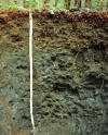
Pittstown Soils: Very deep, moderately well drained soil formed in dense glacial till derived mainly from phyllite, slate, shale, and schist. Pittstown soils are on drumlins, and smooth concave sideslopes of uplands. Pittstown soils occur primarily in the northern portion of the County where the dominant bedrock has dark mineralogy.
Click
for a Soil Profile Picture
Link
to Official Series Description
Pittstown Pedon Description 2334501
Pittstown Pedon Description 2334502
Map
Unit (s): 345A, 345B, 345C, 346A, 346B, 346C
Map
Phases:
Taxonomic
Classification: Coarse - loamy, mixed, mesic, Aquic
Dystrochrepts.
Drainage
Class: Moderately well drained.
Parent
Material: Dense glacial till derived from dark colored
sedimentary rocks.
Permeability:
Moderate in the solum, slow or very slow in the dense substratum.
Available
Water Holding Capacity: Moderate.
Soil
Reaction: Strongly acid to moderately acid throughout.
Depth
to Bedrock: Greater than 65 inches.
Seasonal
High Watertable: Depth: 1.5 to 3 feet.
Type: Perched
Months: December to May.
Hydrologic
Group: C.
Hydric
Soil: No (may have hydric inclusions).
Flooding/Ponding
Potential: Frequency and Type: None.
Potential
Inclusions: Scituate, Birchwood, and Woodbridge soils are
similar inclusions. Poorly drained Norwell, and Ridgebury soils
are along drainageways.Well drained Newport, Paxton, and Montauk
soils are on convex slopes.
Soil Suitability:
Agriculture: Map unit 345B is a prime farmland soil. Map units 345C, 346C and 346B are important farmland soils. Map units 345C and 346C are highly erodible map units
Woodland: Well suited for woodland.
Development: Major limitations related to slow permeability in the dense till substratum and seasonal high watertables. Large surface and subsurface stones and boulders may interfere with excavation. Erosion hazards are likely during development, measures should be taken to prevent erosion.
Back to
Homepage
Back to
Legend