 USGS
Topo Location
Download Monitoring Well locations for viewing with
Google Earth
USGS
Topo Location
Download Monitoring Well locations for viewing with
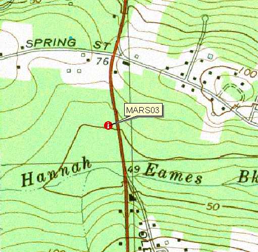
Google Earth| Soil Water Table Monitoring Index well MARS03 - Brockton Soil, Marshfield MA. |
USGS
Topo Location
Download Monitoring Well locations for viewing with
Google Earth |
LOCATION.--Lat 42o09' 16" N, Lon 070o
44' 37"
W NAD 83. Massachusetts State Plane NAD 83, 262,520 Easting, 878,497 Northing.
Plymouth County, Town of Marshfield - 20 meters west of Route 3a., 320 meters
south of Spring St, Audubon Conservation Land. Location geo-referenced with a PLGR GPS.
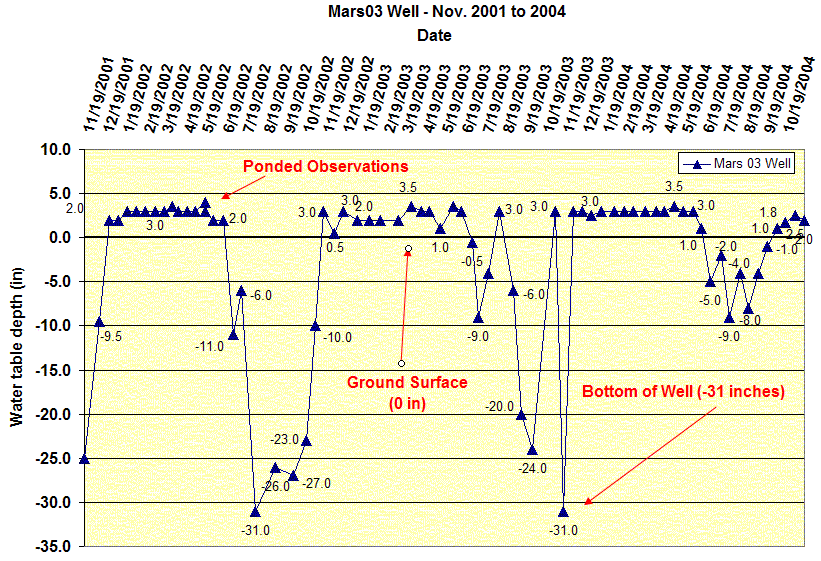
WELL CHARACTERISTICS.--Well type - 2.0 inch diameter screened PVC pipe, total well
depth = 50 inches below the surface. Installed November 01, 2001.
ELEVATION.-- Surface is 15 Meters (50 feet) above sea level, from topographic map
(National Geodetic Vertical Datum of 1929).
SOIL TYPE.--Brockton Series - very
poorly rained soil formed dense basal till. Click for a complete pedon description of the soil log from the
MARS02 well. The estimated average seasonal high water table,
based on soil morphology for this site is 0 inches below the surface based on
soil morphology.
GEOLOGY.-- Lodgement Till.
WELL OBSERVATIONS.--Highest recorded watertable - + 4.0 inches (ponded) above
ground on May 15, 2002 following a 2+ inch rain event. Hydrograph Notes: WT_Depth is the measured depth to water below the ground
surface. Positive numbers indicate the watertable was above the ground surface (ponded). Ground surface datum for these readings is 0, to determine the actual
depth to water below the surface elevation subtract the depth in the table
from 50 feet. The 50 inch depth is the total
depth of the well.
Contact Jim Turenne for more information | Return to Index Wells
Click here to view a presentation about using a
device to measure maximum water table depths (Morgan and Stolt)
USGS Water Resources of
Massachusetts and Rhode Island - Ground-Water Data
WRP Technical Note HY-IA-3.1 Installing Monitoring
Wells/Piezometers in Wetlands