Soil Survey of Plymouth County, Massachusetts
By James D. Turenne, Natural Resources Conservation Service
GENERAL NATURE OF PLYMOUTH COUNTY: This section gives general information about the cultural and natural factors that affect the use, management, and characteristics of the soils in Plymouth County.
Plymouth County, Massachusetts is located in the southeastern part of Massachusetts. Barnstable County, Cape Cod bay and Massachusetts Bay border to the east. Norfolk, Suffolk and Bristol Counties border to the west and north. Buzzards Bay borders the south portion of the county. The survey area consists of 26 towns and 1 city covering approximately 424,960 acres (171,981 hectares), or 661 square miles (approximately 8.5 percent of the land area of Massachusetts).
Population and Land Use:
The 2000 population of Plymouth County is estimated at 472,822 an 8.7 increase from 1990 population (U.S. Census). The population density is 715 persons per square mile (2000 U.S. Census). Plymouth County is the fourth most rapidly populating County in the State. The other three most rapidly populating Counties are all located in southeastern Massachusetts. The dominant land uses of Plymouth County are forestland (predominately non-commercial White and Pitch Pine, Oak, and Red Maple), residential and commercial development, and cranberry agricultural production. The following table summarized the land use of Plymouth County (Mass/GIS Data Viewer, Source: Land Use Map 1985 to 1999, click here for the data layer description - http://www.state.ma.us/mgis/lus.htm).
|
Land Use Category |
Land Use Definition |
Percent of Plymouth County |
| Commercial | General urban; shopping center |
1.33 |
| Cranberry bog | Cranberry Beds |
4.75 |
| Cropland | Intensive agriculture |
2.35 |
| Forest | Forest |
51.00 |
| Industrial | Light & heavy industry |
0.86 |
| Mining | Sand; gravel & rock |
0.67 |
| Openland | Abandoned agriculture; power lines; areas of no vegetation |
2.72 |
| Participation Recreation | Golf; tennis; Playgrounds; skiing |
1.40 |
| Pasture | Extensive agriculture |
1.20 |
| Residential R0 | Multi-family |
0.37 |
| Residential R1 | Smaller than 1/4 acre lots |
2.03 |
| Residential R2 | 1/4 - 1/2 acre lots |
9.47 |
| Residential R3 | Larger than 1/2 acre lots |
9.90 |
| Salt Wetland | Salt marsh |
1.56 |
| Spectator Recreation | Stadiums; racetracks; Fairgrounds; drive-ins |
0.03 |
| Transportation | Airports; docks; divided highway; freight; storage; railroads |
1.17 |
| Urban Open | Parks; cemeteries; public & institutional green space; also vacant undeveloped land |
1.41 |
| Waste Disposal | Landfills; sewage lagoons |
0.21 |
| Water | Fresh water; coastal embayment |
4.54 |
| Water Based Recreation | Beaches; marinas; Swimming pools |
0.16 |
| Wetland | Nonforested freshwater wetland |
2.74 |
| Woody Perenial | Orchard; nursery |
0.13 |
| TOTAL |
100 |
The current land use trend in Plymouth County is the conversion of woodland and cropland to residential housing and commercial uses. Most of the residential development is the construction of large, single-family homes in small to large subdivisions. The commercial development is mainly in the form of shopping centers, malls, and small business complexes. Sand and gravel mining operations and the construction of cranberry beds within the excavated soils is also a large land use trend in the southeastern part of the County.
Through the course of updating the soil mapping within Plymouth County, soil scientists have identified over 260 different soil map units. The soils range widely in texture, depth, drainage, and other chemical and physical properties. This survey is intended to show the distribution of the soil resource and highlight the properties of each soil map unit and their limitations and potentials for various uses.
Physiographic Description:
Plymouth County is divided into two major land resource areas (MLRA). The MLRA is a physiographic region that is similar in climate, topography, water resources, land use, and pattern of soils. The east and southeastern part of Plymouth County are in MLRA 149B - Long Island and Cape Cod Coastal Lowland. The northern and western parts are in MLRA 144A-New England and Eastern New York Upland, Southern Part.
Plymouth County lies mostly within the Seaboard Lowland section of the New England province of the Appalachian Highlands division (similar to MLRA 144A). The southeastern portion of the County is located within the Embayed Section of the Coastal Plain province of the Atlantic Plain division (Hunt, 1967). Elevation ranges from sea level to approximately 400 feet (122 meters) at the summit of Manomet Hill in the town of Plymouth.
The Seaboard Lowland Section is characterized by gently rolling topography with low relief and subtle breaks between major landforms. Bedrock altitudes range from the surface to more than 200 feet below the surface in deep fluvial valleys. The upland hills consist of drumlins and ground moraines composed of glacial till. The valley areas consist of level to steep rolling landforms consisting of glacial fluvial, lacustrine, and swamp deposits.
The Embayed Section is characterized by being very deep to basement rock, ranging from approximately 100 feet in the western part of the section to more than 300 feet in the southeastern part. The section consists of bouldery hills and ridges called recessional moraines (see geology section) and very large level to gently sloping outwash plains pitted with numerous kettle holes.
The County has some less extensive physiographic areas, which include swamps, beaches, dunes, and tidal marshes. Most of the shoreline is fringed with sand and cobble beaches. Areas of tidal marshes are inland from beaches and sand dunes, and generally fringe salt-water inlets and tidal streams. Duxbury Marsh and the North River Marsh in the towns of Duxbury and Marshfield contain the most extensive area of tidal marsh in the County. The Hockomock swamp, which also extends into Bristol County, is the largest peatland area in Massachusetts. The Hockomcok is located in a depression or basin of glacial lake Taunton and consists of shallow and deep organic soils and alluvial soils underlain by thick deposits of silts and clays.
Water Supply and Drainage:
Water supply to towns and cities in Plymouth County comes from surface waters (lakes, ponds and reservoirs), ground water wells located in sand and gravel aquifers and from deep bedrock wells. There are over 450 ponds, lakes and reservoirs in Plymouth County totaling approximately 19,970 acres. Their size ranges from less than an acre to over 2,000 acres. Assawompset pond located in the southwestern part of the County covers over 2,500 acres and is the largest natural body of fresh water in Massachusetts. Assawompset pond supplies water to the city of New Bedford in Bristol County. Silver Lake supplies water to the city of Brockton in Plymouth County. A large supply of water is contained in the 140 square mile Plymouth-Carver aquifer, which is the second largest aquifer in areal extent in Massachusetts. The Plymouth-Carver aquifer contains more than 500 billion gallons of fresh water. Water quality and quantity is a major issue facing the County. Water bans are common in many towns during the months of June to October, particularly in the northern part of the county. Surface water supply is threatened by contamination from urban runoff and from residential septic systems. Subsurface wells are threatened from drawdown due to over pumping, contamination from agriculture, urban and residential uses.
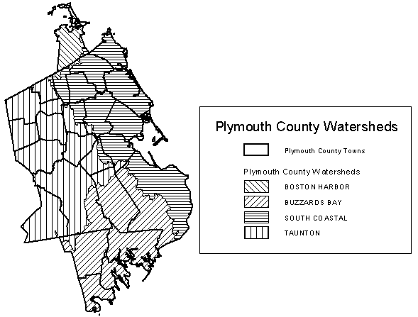
Four major watersheds (Figure 1) drain Plymouth County. The central and western parts are drained by the Taunton River Watershed, which drains into Narragansett Bay. The South Coastal Watershed drains the eastern parts of the county into Cape Cod and Massachusetts Bay. The Boston Harbor Watershed drains the northwestern part of the county into Boston Harbor. The Buzzards Bay Watershed drains the southern part of the County into Buzzards Bay. The four watersheds are drained by numerous small rivers, streams, and aquifer discharge points.
Figure 1: Plymouth County Watersheds
Back to Plymouth County Soil Survey