Background: On November, 2003 soil temperature data loggers were buried to a depth of 20
inches (50 cm) at four sites in RI. The loggers were retrieved this November
(2004) and the data downloaded. Two of the loggers (URI Bog and Jamestown Stissing soil), failed to record data due to dead batteries. Below is the data
from the two sites which recorded soil temperature for most of the year.
Climate summary for the Fall 2003 through 2004 season (visit
http://www.erh.noaa.gov/box/ for more
information: The winter of 2003/2004 saw below average temperatures and average
precipitation. January had several prolong periods in the single digits and some
record lows were set. Spring was cold and wet, summer was average temperatures
but there were no heat waves and temperatures never got above 90 F.
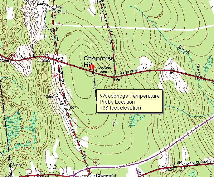
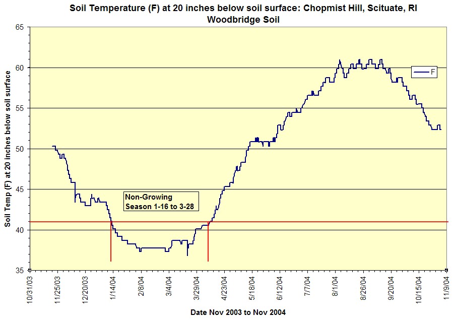
Chopmist Hill Soil Temperature (at 20 in/50 cm below the ground surface)
Data: Woodbridge Soil Series.
Soil Type:
Woodbridge, 0 to 3 percent slope (moderately well drained soil formed in
dense lodgment till) Location: Summit of Chopmist Hill, Clayville USGS Topoquadrangle,
41.8415°N, 71.6711°W (WGS84/NAD83) Soil Temp. at 20 Inches Summary: For the period monitored the growing
season (soil temp at 20 inches > 41F) ended on Jan. 16, 2004 and began on
March 28, 2004. The mean annual soil temperature was 49 F (9.4 C) which is
the mesic soil temperature regime.
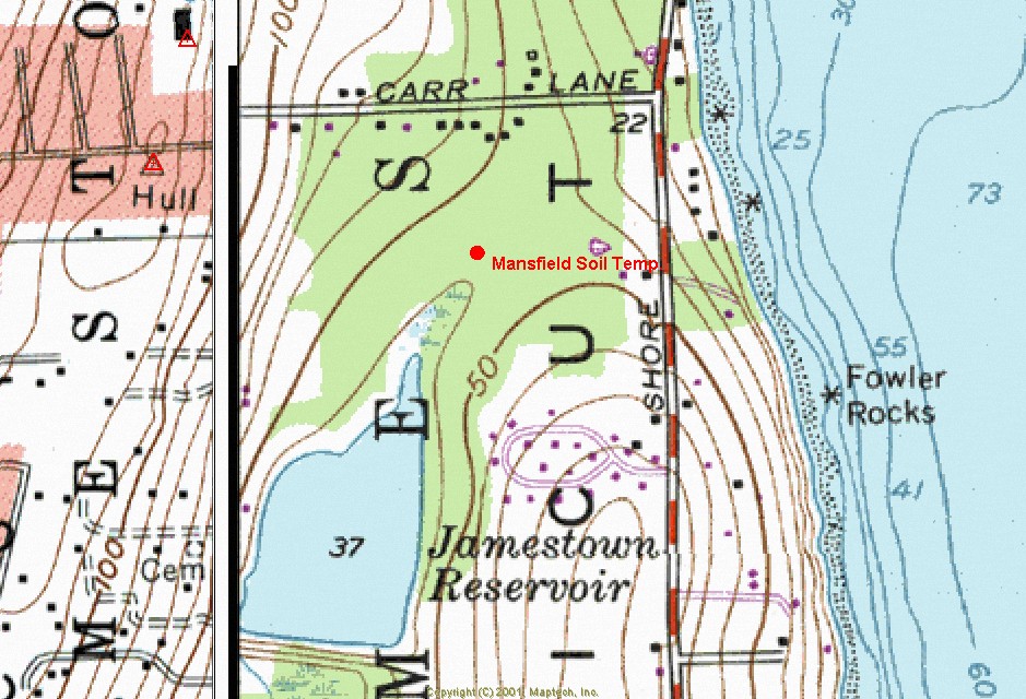
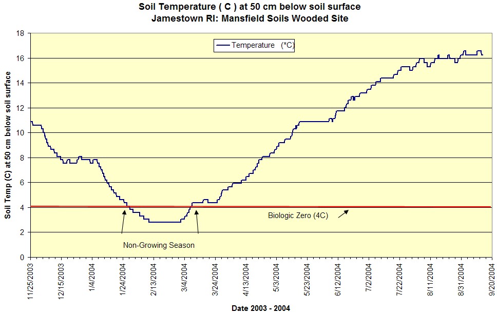
Jamestown Soil Temperature (at 20 in/50 cm below the ground
surface) Data: Mansfield Soil Series:
Soil Type:Mansfield,
0 to 3 percent slope (very poorly drained soil formed in dense lodgment till
derived from carboniferous sediments) Location: Prudence Island USGS Topographic quadrangle, town of
Jamestown, 41.5356°N, 71.3704°W (WGS84/NAD83) Soil Temp. at 20 Inches Summary: For the period monitored the growing
season (soil temp at 20 inches > 41F) ended on Jan. 24, 2004 and began on
March 25, 2004. The mean annual soil temperature was 48.8 F (9.3 C) which is
the mesic soil temperature regime.
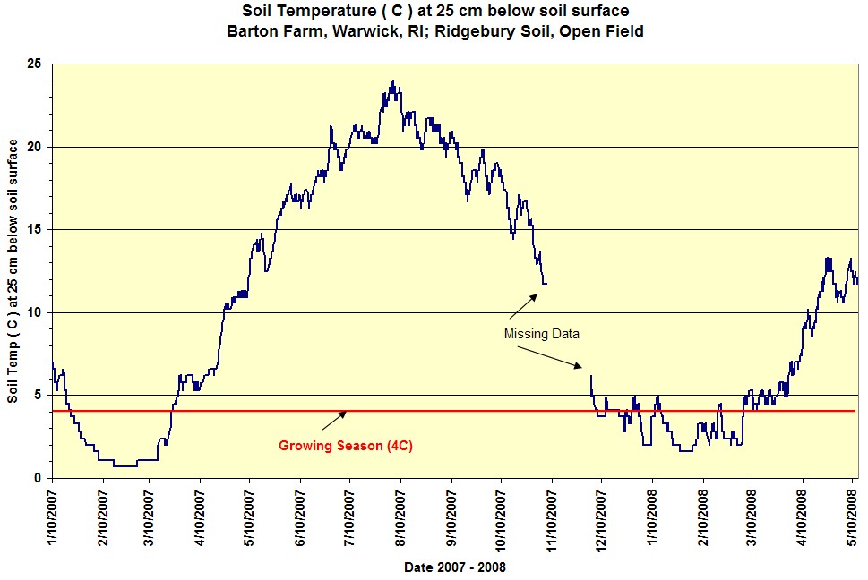
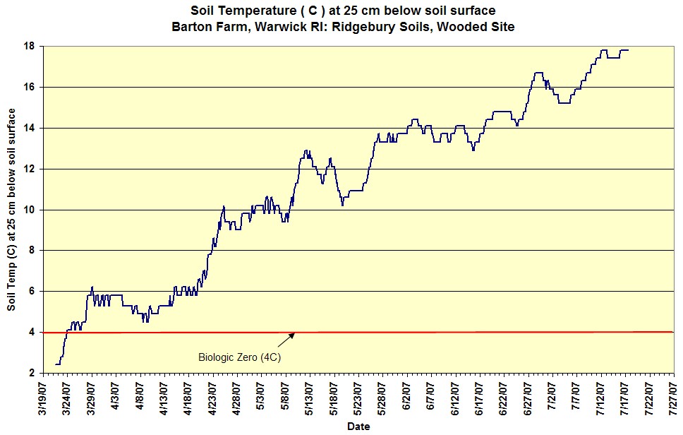
Soil Temperature Study Site:
Barton Farm, Warwick, RI - Ridgebury
Soils
Soil Type: Ridgebury Series. Mesic Soil Temperature
Regime. Pedon Description: Check Back | OSED:
http://www2.ftw.nrcs.usda.gov/osd/dat/R/RIDGEBURY.html
Water Table Data: Check Back Location: 41 41' 57.79"N, 71 30' 39.97"W (field site) and 41 41'
58.52N, 71 30' 48.43"W (wooded) Summary: Hobo Loggers were installed at 25 cm below the soil
surface, one logger was located in an open field the other in a wooded site.
Soil temp readings were taken ever 5 hours. For the open field site the growing season
ended 1/22/2007 and began 3/24/2007. For the wooded site the growing season
began 3/27/2007.
Soil Type: Mashpee Series. Mesic Soil Temperature
Regime.
Water Table Data: Check Back Location: 41.469744, -71.578003 Summary: Hobo Loggers were installed at 12 inches below the soil
surface, soil temp data has been monitored since 2010 at the Great Swamp
TA-6 monitoring well site.