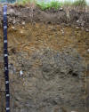
Woodbridge Soil Profile Image
PLYMOUTH COUNTY, MASSACHUSETTS SOIL SURVEY UPDATE
Woodbridge Soils: Very deep, moderately well drained soil formed in compact glacial till. Woodbridge soils are on the smooth top slopes, upper side slopes and toe slopes of glaciated hills.
Link
to Official Series Description
Click here for Woodbridge
Laboratory Data S91-MA-023-007, Pedon
Description for Lab Site |
Water table data for a Woodbridge Soil
(SCIT01) | Water table data for a Woodbridge Soil
(MARS02) | Water table data for a Woodbridge Soil
(DEG) |
Woodbridge profile description 2331001 | Woodbridge profile description 2331002 | Woodbridge profile description 2331005 |Woodbridge profile description 2331006 | Woodbridge profile description 2331109
Map
Unit (s): 310A, 310B, 310C, 311A, 311B, 311C
Map
Phases:
Taxonomic
Classification: Coarse - loamy, mixed, mesic, Aquic
Dystrochrepts.
Drainage
Class: Moderately well drained.
Parent
Material: Dense glacial till.
Permeability:
Moderate in the solum, slow or very slow in the dense substratum.
Available
Water Holding Capacity: Moderate.
Soil
Reaction: Very strongly acid to moderately acid throughout. .
Depth
to Bedrock: Greater than 65 inches.
Seasonal
High Watertable: Depth: 1.5 to 3 feet.
Type: Perched
Months: November to May.
Hydrologic
Group: C.
Hydric
Soil: No (may have hydric inclusions).
Flooding/Ponding
Potential: Frequency and Type: None.
Potential Inclusions: Scituate, Birchwood, and Newfields soils are similar inclusions. Poorly drained Norwell, Sippican, and Ridgebury soils are along drainageways. Well drained Paxton, Poquonock and Montauk soils are on convex slopes.
Soil Suitability:
Agriculture: Map units 310A and 310B is a prime farmland soil. Map units 310C, 311A, 311B and 311C are important farmland soils. Map units 310C and 311C are highly erodible map units.
Woodland: Well suited for woodland.
Development: Major limitations related to slow permeability in the dense till substratum and seasonal high watertables. Large surface and subsurface stones and boulders may interfere with excavation. Erosion hazards are likely during development, measures should be taken to prevent erosion.
Back to
Homepage
Back to
Legend