 Click
to see a Birchwood Soil Profile
Click
to see a Birchwood Soil ProfilePLYMOUTH COUNTY, MASSACHUSETTS SOIL SURVEY UPDATE
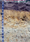
Birchwood Soils: Very deep, moderately well drained soil formed in sandy eolian deposits underlain by loamy dense glacial till. Birchwood soils are on the lower side slopes and toe slopes and on gently sloping areas of ground moraines and drumlins.
Click
to see a Birchwood Soil Profile
Link
to Official Series Description
Birchwood
laboratory data S93-MA-023-003 |
Click for Pedon
Description | Photo of this Pedon
Birchwood
laboratory data S94-MA-023-003 |
Click for Pedon
Description |
Water table Data from Mattapoisett
Monitoring Well | Water table data from Eames
Way site |
Birchwood Soil Interpretation
Record (SOIL5)
Birchwood Profile Descriptions:
2332001 | 2332002 |
2332003 |
2332004 | 2332105 |
2332106 | 2332107 |
2332108 | 2332109 |
2332010 (Pedon
from above photo) | 2332111 |
S942308
Map Unit (s): 320A, 320B, 320C,
321A, 321B, 321C
Map Unit Phases:
Taxonomic Classification:
Sandy over loamy, mixed, nonacid, mesic, Aquic Udorthents.
Drainage Class: Moderately
well drained.
Parent Material: Sandy eolian
and/or fluvial material underlain by loamy dense glacial till.
Permeability: Moderately
rapid to rapid in the solum, slow to very slow in the dense
substratum.
Available Water Holding Capacity:
Low.
Soil Reaction: Very strongly
to slightly acid throughout.
Depth to Bedrock: Greater than 65
inches.
Seasonal High Watertable: Depth:
1.5 to 3 feet.
Type: Perched.
Months: November to April.
Hydrologic Group: C.
Hydric Soil: No (may have
hydric inclusions).
Flooding/Ponding Potential: Frequency
and Type: None.
Potential Inclusions:
Moderately well drained Woodbridge, Scituate, and Newfields soils
are on similar landforms. Poorly drained Norwell, and Ridgebury soils are on lower elevations and along drainage-ways.
Well drained Paxton, Poquonock and Montauk soils are on convex
slopes and on higher elevations.
Soil Suitability:
Agriculture: Map unit 320A and 320B are prime farmland map units. Map units 320C, 321A and 321B are important farmland map units. Limitations for Birchwood soils are related to droughtyness, irrigation is needed for optimal yield. Surface (map units 321) and subsurface stones and boulders may cause problems with farm equipment.
Woodland: Well suited for woodland.
Development: Major limitations related to slow permeability in the dense till substratum and seasonal high watertables. Large surface and subsurface stones and boulders may interfere with excavation. Erosion hazards are likely during development, measures should be taken to prevent erosion.
Back to Homepage
Back to Legend