Soils are formed through the interaction of five major factors:
time, climate, parent material, topography and relief, and
organisms. The relative influence of each factor varies from
place to place, but the combination of all five factors normally
determines the kind of soil developing in any given place. In
Plymouth County parent material and relief as it relates to
drainage, account for many of the differences among the named
soils. The following are brief explanations of the factors
contributing to soil formation in Plymouth County Massachusetts.
Time: The formation of soils is a continuing process and
generally takes several thousand years for significant changes to
take place. The soils of Plymouth County began to develop
immediately after the ice retreat of the last glaciation (Pleistocene),
approximately 14,000 years ago. The soils are considered to be
relatively young soils with slight alteration of parent material
and weak soil horizon development. Most of the soil orders mapped
in Plymouth County are Inceptisols, Entisols, and Spodosols.
Climate: Climate, particularly temperature, precipitation and
frost action have a profound influence on the soil forming
processes which occur within a region. The kind of climate
largely determines the nature of the weathering processes that
will occur and the rates of these chemical and physical processes.
It directly affects the type of vegetation in an area which in
turn will affect those soil forming processes related to
vegetation. Plymouth County is in a transitional climate zone
with conditions characteristic of both humid marine and humid
continental climates. The winters are quite mild for New England
due to the moderating effect of the surrounding Atlantic waters.
Temperature and precipitation (approximately 40 in/yr.) govern the rate of chemical and
physical weathering of the soils and allows for the accumulation
of organic matter in the surface layer of the soils. Moisture is
sufficient enough to promote leaching of water-soluble material
down through the soil. Cold winter temperatures allow for frost
action which physically break apart rock fragments.
Parent Material: Link to General Geology
of Plymouth County, Massachusetts Parent material is the unconsolidated mineral and
organic deposits in which soils are developing. It determines the
mineralogical composition and contributes largely to the physical
and chemical characteristics of the soil. The kind of parent
material also influences the rate at which soil forming processes
take place.
Due to the effects of the Wisconsinan glaciation, insufficient
time has elapsed to significantly alter the glacial deposits. The
influence of parent material is very apparent in the soils of
Plymouth County. Parent material is roughly divided into two
broad groups; glacial (Late Pleistocene) deposits and post glacial (Holocene)
deposits. There are four general types of glacial deposits
recognized in the survey area, they are; till,
fluvial, lacustrine, and ice-contact deposits. Post
glacial deposits are sediments which were deposited after the
last glacial period which ended approximately 10,000 years ago.
Post glacial deposits recognized in the survey area include,
eolian silts and sands, alluvial (floodplain) deposits,
freshwater and marine organic deposits, and coastal beaches and
sand dunes desposits.
Glacial till is dominantly unsorted and unstratified sediments,
deposited directly (beneath and within) by glacial ice. Till consists of a
heterogeneous mixture of clay, silt, sand, gravel, stones and
boulders. Two broad groupings of till have been recognized by
soil scientists in Plymouth County. One is referred to as dense
or basal till and is characterized by a loamy texture, with a
moderate percentage of coarse fragments, and a dense, firm,
slowly permeable substratum; locally referred to as hardpan. The
Paxton and Montauk soils are
representative soils that developed in these sediments. The other
till referred to as ablation till, has a sandy texture, with a
high percentage of coarse fragments, and a loose, permeable
substratum. The Gloucester and Canton soils are representative
soils that developed in this material.
Glacial fluvial (outwash) material is
stratified sand and gravel deposited by glacial meltwater streams.
Soils that have developed in glacial outwash have a sandy or
gravelly, loose, very permeable substratum. Glacial fluvial deposits are
associated with aquifer recharge areas. Soils commonly mapped
in glacial outwash areas include Carver, Hinckley and
Merrimac soils. Click here for a glacial fluvial
landform image.
Glacial lacustrine, commonly referred to as lakebed deposits
are varied ranging from sands and gravels to silts and clays.
These materials were deposited within glacial lakes which have
since drained or have filled with sediments. Soil patterns are
complex within these areas and often vary dramatically, both
chemically and physically, over short distances. Soils that have
developed in glacial lakebed deposits include the Scio,
Hinesburg,
Raynham and Birdsall
soils.
Ice contact deposits are varied ranging from till to bouldery
sand and gravel. These materials were deposited in contact with
an ice mass. Examples of ice contact features include;
kames,
heads of outwash, and kettles. Soils that have developed in ice
contact deposits include the Plymouth, Barnstable, Canton, and
Hinckley soils.
Post glacial eolian sediments are sand and silt deposited by
wind during the period after the glacial ice melted from the area
and before a permanent vegetative cover was established,
stabilizing the newly exposed land surface. Eolian sands and silt
occur as a discontinuous mantle or cap, variable in thickness,
over glacial deposits. Most of the upland soils in Plymouth County
are capped with an eolian mantle. Haven soils
developed in areas where this mantle is thick (18 to 36 inches)
and overlies glacial outwash. The loamy surface and upper solum
of the Barnstable and Merrimac soils is the result of a thin
capping of eolian material that has been mixed, through natural
processes, with the underlying material. Carver soils have
a coarse sand eolian mantle.
Organic deposits are accumulations of plant materials of
varying degrees of decomposition that have formed in wet areas
and are 16 inches or greater in thickness. The Freetown and
Swansea soils developed in freshwater organic deposits. The
Ipswich and
Pawcatuck soils developed in organic tidal marsh deposits.
Alluvial deposits are recent material which has been deposited
by flowing water. Alluvial deposits occur along the major rivers
of the county. The Winoski and Limerick soils are examples of
alluvial soils.
Beaches are unvegetated, wave washed accumulations of sand
that do not meet the criteria for a soil and are mapped as a
miscellaneous area. Sand dunes are windblown deposits of sand.
Hooksan soils developed within areas of sand dunes.
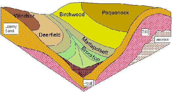
Topography and Relief The shape of the land surface, its slope and position
on the landscape, greatly influence the kinds of soils formed. In
Plymouth County soils that formed in similar parent materials
with the same climatic conditions exhibit differences as a result
of their position on the landscape. These differences are largely
a result of varying drainage conditions due to surface runoff or
depth to water table.
Soils that developed on higher elevations and sloping areas
are generally excessively drained or well drained. Depth to
groundwater is generally greater than 6 feet and surface runoff
is moderate or rapid. Soil profiles within these areas commonly
have a bright colored strong brown to yellowish brown upper solum
grading to a lighter, grayer, unweathered substratum.
Soils that occur at lower elevations such as in swales,
adjacent to drainage-ways and water bodies, and within
depressions generally receive surface runoff from higher
elevations and often have a seasonal high water table at a
shallow depth. Soil profiles within moderately well drained and
poorly drained areas are mottled with irregular spots of brown,
yellow and grey colors. In very poorly drained areas, where the
water table is at or near the surface for prolonged periods, soil
profiles characteristically have a dark-colored organic or
organic rich surface layer underlain by a strongly mottled or
gleyed (gray color indicating a reduced condition) subsoil and
substratum.
Permeability of the soil material; as well as the length,
steepness, and configuration of the slopes, influence the kind of
soil that is formed in an area. The local differences in the
soils mapped in Plymouth County are largely the results of
differences in parent material and topography.
Organisms All living organisms actively influence the soil
forming process. These organisms include bacteria, fungi,
vegetation and animals. Their major influence is the effect on
the chemical and physical environment of the soils.
Most, if not all of Plymouth County, was originally in native
forest of mixed hardwoods and conifers in varying proportions.
The mineral element content of leaves and branches varies
depending on the type of forest vegetation, and influences the
characteristics of the soils that develop beneath it. Hardwoods
characteristically take up bases (calcium, magnesium, and
potassium) from the soil and return them to the soil surface in
the form of organic litter; thus recycling the soil nutrients.
Coniferous trees tend to be low in bases, consequently soils
developed beneath them tend to be more acid. Bases are also more
susceptible to leaching beneath coniferous trees. Mixing of the
soil, due to tree throws, is also a characteristic of woodland
soils.
Some types of micro-organisms promote acid conditions and
change the chemistry of the soil which in turn influences the
type of soil forming processes that take place. Microbial animals
decompose organic materials and return the products of
decomposition to the soil.
Larger animals such as earthworms and burrowing animals mix
the soil and change its physical characteristics. They generally
make the soil more permeable to air and water. Their waste
products cause aggregation of the soil particles and improve soil
structure.
Man's activities have significantly altered many areas of
natural soils in the county. The chemical and physical properties,
particularly of the plow layer, have changed with cultivation and
the addition of lime and fertilizer. Artificial drainage and
filling have altered the environment of some naturally wet soils.
Of all the animals, man can have the most beneficial or most
detrimental impact on the soil forming processes.
The interaction of the five soil-forming factors; time,
climate, parent material, topography, and plant and animal life,
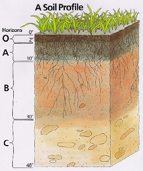
result in the development of a soil profile. A soil profile is a
vertical section of the soil beginning at the surface and
extending down into the unconsolidated underlying material to a
depth of 60 inches or more. A soil horizon is a layer of soil,
approximately parallel to the soil surface, with distinct
characteristics produced by soil-forming processes. The physical
and chemical characteristics observed within the soil profile are
the basis for differentiating one soil from another.
The majority of the soils within the survey area exhibit weak
soil profile development with little change or alteration of
parent material, due primarily to the relatively young age of the
soils. The depth of soil profile development varies between the
different soils and generally averages about 30 inches in the
well drained soils.
Soil profile development is generally shallower in the poorly
and very poorly drained soils, and may be absent or very weak in
recently deposited material, as in the case of the Hooksan soils.
Organic matter has accumulated on the surface of soils as O-horizons
with varying degrees of thickness and decomposition. Where
natural mixing of humified organic material and the underlying
mineral matter has occurred, an A-horizon is present. The amount
of organic matter added to the soils in the survey area varies
with the kind of vegetation, moisture, and drainage condition.
The thick, mucky, organic deposits that the Freetown and Swansea
soils are developing in are the result of a very poorly drained
condition where organic material accumulates within this very wet
environment rather than being oxidized. In areas that have been
cultivated, the surface organic layers and the upper solum of the
soil have been mixed to form an Ap-horizon.
The soil profile development characteristic of many
excessively drained, well drained, and moderately well drained
soils mapped in the survey area is the result of movement and
deposition of aluminum, iron, clay, and humified organic matter
within the soil profile. Weak organic acids generated from the
decomposition of surface organic litter are percolated downward
through the soil by rainwater. Aluminum and iron within the upper
portion of the soil profile are released into solution and
leached downward, along with fine particles of humified organic
matter and small amounts of fine clay. The light gray color in
the E-horizon (surface mineral horizon below the O-layers or A-horizon)
has resulted from this leaching and is more evident in the
coarser textured soils and often absent in the finer textured
soils. With depth, the chemical environment within the soil
changes and the aluminum, iron, clay, and organic material
precipitate out forming the B-horizons. The greatest
concentration of leached material precipitates out just below the
E-horizon and often forms a strong brown Bhs or Bw1 horizon.
Undisturbed soil profiles of Carver, and
Montauk soils commonly
have an E-horizon underlain by a brightly colored B-horizon. The
characteristic dark brown to yellowish brown color within the
subsoil is due primarily to iron oxide stains on the surfaces of
sand-size particles. Color within the subsoil generally fades
with depth. The unweathered parent material in the C-horizon is
often light yellowish brown or light olive brown.
Where there is a water table that is within or fluctuates
within the soil profile, there are soil color changes referred to
as soil mottling. Soil mottles are the combination of gray and
reddish spots produced by alternating aerated and saturated
conditions (oxidation-reduction process) within the soil profile.
These spots are caused principally by migration, depletion or
concentration of iron within the soil (Soil Survey Manual).
Gleying is a condition that develops when the soil is wet for
most of the year and the soil matrix color is gray or bluish gray
due to the removal of iron caused by prolonged reducing
conditions. Soil mottling is common in the upper solum of the
poorly drained Ridgebury and Walpole soils; and in the lower
portion of the solum in the Scio, Scituate, Deerfield and
Sudbury
soils. Gleying is characteristic of the very poorly drained Birdsall soils.
Induration of sand grains caused by the concentration of iron (ferric)
occurs within the soil profile of some of the very poorly drained
Berryland soils.